|
|
 |

When we first begin our exploration of winegrowing areas of France, we study them as parts of larger regions. For instance, we learn that Pauillac is part of the larger Bordeaux region, Gigondas part of the Rhône, and so on. Thus, we learn about Chablis as a subset of Burgundy, even though it is geographically removed from the Côte d’Or. We learn about the Aube as part of Champagne, even though it is quite a bit south of the Côte des Blancs and other areas. We study as well the Central Vineyards of the Loire as the eastern outlier of the greater Loire viticultural region. Champagne, Burgundy and the Loire, however, are all tied together by their geologic roots -- sharing the distinctive lithology and the resultant soils of the Kimmeridgian. This sequence was dubbed the “Kimmeridgian Chain” by the late James E. Wilson in his excellent 1998 book, Terroir.
The legend of the Kimmeridgian has assumed mythical proportions in wine circles. Exalted as the bedrock and soil source of Grand Cru Chablis, the mere suggestion of Kimmeridgian origins brings knowing nods among wine aficionados. There is a presumption here of a more absolute entity than close inspection will support. The term Kimmeridgian is a label that is applied to a sequence of rocks of a specific age. The actual components of those rocks can vary substantially from place to place. The surface exposures of the Kimmeridgian span hundreds of miles and it is easy to understand that the landscapes and weather during Kimmeridgian times were no more uniform than they are today, and that we should expect noticeable differences over great distances.
Let’s look at the Kimmeridgian from a geologic perspective, so we can get a better sense of why this particular formation is so conducive to quality wine production. Understanding geologic time is a struggle for most who have not devoted a lot of time to geologic studies. If a human lives a hundred years, it’s considered a long life. It is natural to consider our observations on the scale of our temporal existence. Thus, processes that take millions of years to transform the physical world are rather incomprehensible. We presume that the earth is stable. In a human lifetime, that is generally true -- we only catch an occasional glimpse of the sometimes-cataclysmic geologic forces at work. In a geologic sense, however, the earth is a dynamic and ever-moving sphere, with massive forces competing for ascendance over each other.
John McPhee, in his book Annals of the Former World captures the conundrum of understanding geologic time quite well:
“Numbers do not seem to work well with regard to deep time. Any number above a couple of thousand years--fifty thousand, fifty million--will with nearly equal effect awe the imagination to the point of paralysis.”
That summarizes the common reaction of individuals when they read that a mountain, or fossil, or other geologic artifact is 100 million years old. To help grasp the meaning of geologic time in a philosophic sense, McPhee suggests:
“If you free yourself from the conventional reaction to a quantity like a million years, you free yourself a bit from the boundaries of human time. And then in a way you do not live at all, but in another way you live forever.”
As geologists, freed from the boundaries of human time, we learn about the Kimmeridgian as both a specific rock formation and a time horizon -- an Age within the Late Jurassic Epoch of the Jurassic Period of the Mesozoic Era of the Phanerozoic Eon.

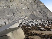
Kimmeridgian Exposure at Kimmeridge Bay
The Kimmeridgian covers a mere five million years -- from 152 to 157 million years ago -- of the fifty million year span of the entire Jurassic Period. The world was a very different place then. The rocks and distinctive fossils that comprise the Kimmeridgian were first described at the village of Kimmeridge, on the south coast of Great Britain, which is the northern edge of what we now call the Paris Basin. It was named the Kimmeridgian Clay, because the clay component is primary there.
The clay in that part of the world is rich with organic compounds and as it was buried and compressed into rock, those organic compounds became the source of the prolific oil fields of the North Sea. On the French side of the Paris Basin during Kimmeridgian times, the conditions were quite different. The North American continent had just begun to separate from Europe and the area that is now northern France was a shallow sea, teeming with aquatic life. Conditions in the shallow waters were more turbulent and the resulting rocks show more limestone and seashell components than those across the Channel. The happy result for wine drinkers was a rock sequence yielding soils with a composition and water retention capacity that vitis vinifera vines love.

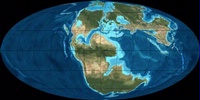
The Earth During Kimmeridgian Times
The pale blue area at the center of the fragmenting supercontinent represents the Paris Basin, a center of deposition for sediments from the nearby land masses. Much as the Gulf of Mexico now collects sediment deposits from the entire central US via the Mississippi River, so too the Paris Basin was a collecting basin for sediments from the high ground.
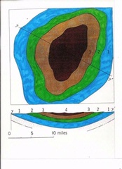
A basin is a bowl. Represented in simplified form below, we can see that the oldest sediments are on the bottom of the bowl and the youngest fill in the top. The Paris Basin subsided and was compressed and transformed from loose sediments into rock. When earth movements brought these rocks to the surface, they were exposed in concentric rings, with the older rocks (blue, in our schematic diagram) on the outside of the circle and the youngest (dark brown) at the center.

A Simplified Geologic Basin
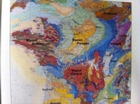
If we take this simplified basin schematic to a real-world application, we can see a very similar, concentric circle form, in the Paris Basin on the geologic map of France.

Geologic Map of France
If we look at the green/blue color boundary, that is the Kimmeridgian outcrop on the outer edge of the Basin. In the places where rivers cut through the outcrop and expose the Kimmeridgian slopes to the sun, we find the several winegrowing regions associated with Kimmeridgian soils.
A closer look at the edge of the basin shows that the Aube is on the eastern end and 75 miles or so south of the Marne growing areas of Champagne. Chablis is next along the chain, part of Burgundy, but 75 miles north of Beaune. Moving east from Chablis, we come to Sancerre and Pouilly Fumé, part of the Loire but some 100 miles removed from the growing areas of Touraine.
Despite the distances separating these divergent areas, the Aube, Chablis, and Central Vineyards share a geologic heritage along the Kimmeridgian outcrop on the south side of the Paris Basin, and we can argue that they share a wine style as well. We can find a common, mineral-driven thread throughout the Pinot Noir based Champagnes of the Aube, the magnificent Chardonnays of Chablis, and the singular Sauvignon Blancs of Chavignol and other Kimmeridgian based communes in Sancerre. It is not just the soil, however. The proper drainage and aspect to the sun, among other factors, is also required for winegrowing endeavors to succeed. An exploration along the Kimmeridgian Chain is well worth making, if only for the quality of the wines.
|
 |
|